
How Slovakia's Military Forest is Improving Wildfire Detection using Autonomous Drones

Slovakia's Military Forest (VLM) is a state-owned company responsible for managing extensive forest and agricultural land within military training areas, with significant holdings of 63,000 hectares across four regional branches. As an organization operating under the Ministry of Defense, VLM faces unique challenges in managing forest resources while adhering to strict security protocols. VLM has taken a progressive approach by integrating autonomous drone technology to bolster monitoring and security in the Záhorie Military District - an area that has served as a key military training space since 1950.
During one of the NestGen ‘25 sessions, we spoke with Michal Severa, CEO of UAVONIC, a leading provider of drone technologies based in Bratislava, Slovakia. UAVONIC specializes in aerial technologies, providing drone-based solutions for construction, energy, and industrial applications with expertise in drone integration, automation, and data collection. Here's what they had to say about implementing automated drone solutions for wildfire detection 👇
The Challenge
"Understanding the factors of highly flammable pine forests combined with dry conditions and strong winds is essential for developing effective prevention and response strategies." - Michal Severa, CEO, UAVONIC
The Záhorie region of Western Slovakia presents significant wildfire risks due to:
- Highly Flammable Landscape: The area is covered by large pine forests which are extremely flammable, especially when combined with dry conditions and strong winds.
- Historical Wildfire Damage: Past incidents have resulted in substantial destruction, including a 1994 wildfire that burned 1,171 hectares, a 2007 fire that destroyed three hectares, and a 2012 fire that consumed 200 hectares of pine forest.
- Detection Limitations: Traditional wildfire detection methods have significant drawbacks. Satellite-based technology provides large-scale tracking but limited early warning capabilities. Lookout towers are restricted by the area they can cover, and citizen reports, while helpful, often come too late when the reporter is already in danger.
- Response Time Criticality: The rapid spread of wildfires demands immediate and accurate information for effective firefighter response, creating an urgent need for faster detection and assessment capabilities.
The sandy terrain of the region compounds these challenges, making fires particularly difficult to combat once they grow beyond initial stages. This creates a critical need for early detection systems that can identify wildfires in their earliest phases to prevent major destruction.
The Solution
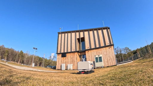
UAVONIC implemented an autonomous drone system for VLM using DJI dock technology integrated with FlytBase software. This drone-in-a-box solution enables continuous, automated monitoring of the Záhorie Military District's 27,000 hectares of forest.
The solution components include:
- Hardware: DJI dock station with Mavic 3T drone equipped with both visual and thermal cameras
- Software: FlytBase on-premise solution for secure autonomous operations
- Integration: Custom mapping integration with VLM's forest management system
- Communication: Starlink connectivity for data transmission
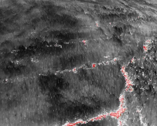
The system leverages advanced thermal imaging to detect heat anomalies, providing a significant improvement over traditional detection methods. By operating autonomously, the drones can conduct regular patrols on predetermined flight paths, significantly increasing the chances of early wildfire detection.
How it works
The DJI dock station houses the drone and serves as its charging and data offloading station
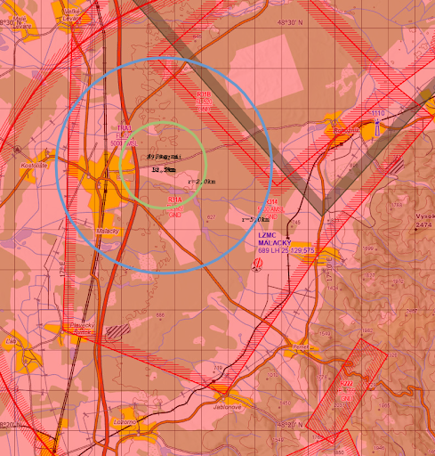
- The system runs automated missions at regular intervals, covering a 2-3 kilometer radius from the dock
- The drone captures both visual (4K) and thermal imagery (640×512 pixels) during flights
- Data is transmitted back to the dock using DJI's transmission system within the operational range
- The dock uploads the captured data via Starlink to FlytBase servers for processing
- If a potential fire is detected, the system alerts operators who can verify the threat and coordinate with firefighting teams
- In future implementations, AI-based detection will further automate the identification of heat anomalies
The system operates within strict airspace and technical constraints, maintaining a maximum flight altitude of 120 meters above ground level while still providing effective coverage. The thermal imaging capabilities extend the effective monitoring range up to 5 kilometers, allowing for precise wildfire detection and situation awareness.
Implementation
Implementing the drone-in-a-box solution in military-controlled airspace presented multiple challenges. UAVONIC conducted initial tests over several days in August to evaluate actual radio signal range and collect video and photo footage to verify optimal flight parameters. Testing under real conditions (35°C+ temperatures) was essential to validate technical specifications and operational parameters.
The implementation process required overcoming several key challenges:
- IT Security Integration: As a state-owned company under the Ministry of Defense, VLM follows strict military standards for IT security. Creating a network architecture that satisfied both VLM's security requirements and FlytBase's operational needs was a significant challenge, requiring careful coordination between VLM's IT team and FlytBase developers.
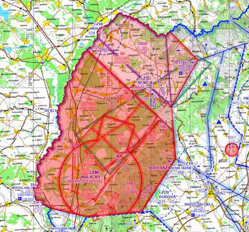
- Airspace Coordination: Operating in restricted airspace (LZR 314) required establishing procedures for continuous communication with Malacky Air Traffic Control and coordination with military training activities at the Zuzana firing range, which operates in the same altitude zone.
- Technical Limitations: While the theoretical maximum range of the system is 15 kilometers (8 kilometers under European CE standards), practical operations are limited to a 2-2.5 kilometer radius due to ground-level positioning and signal obstruction by trees. This required strategic placement of the dock station to optimize coverage while ensuring reliable operation.
Impact
The implementation of the autonomous drone system has delivered significant benefits for VLM's wildfire management capabilities:
Enhanced Monitoring Coverage
The system provides regular aerial monitoring of the forest area within a 2-3 kilometer radius of the dock, with thermal detection capabilities extending effective coverage up to 5 kilometers.
Improved Early Detection
Regular autonomous flights increase the probability of detecting wildfires in their initial stages when they're most manageable.
24/7 Readiness
The drone-in-a-box system ensures continuous availability for immediate deployment when fire risks are detected, reducing response times.
Reduced Human Resource Requirements
The autonomous nature of the system minimizes the need for human operators, allowing VLM to allocate personnel to other critical tasks.
Better Situational Awareness
The system provides real-time aerial views that help responders understand fire size, direction, and intensity, improving tactical decision-making.

"Only based on real tests can you check what is written in the technical specifications. We were happy that VLM asked us for these tests, and we performed them to show that really the DJI dock and FlytBase is the right solution to be implemented into regular operation." said Michal Severa, CEO, UAVONIC.
Way Ahead
UAVONIC and VLM are working on several enhancements to further improve the system's capabilities:
- AI Integration: Implementing machine learning for automated fire and smoke detection to reduce reliance on human monitoring, making detection faster and more efficient.
- Multi-Dock Deployment: Plans to expand the system by installing additional dock stations across VLM's four operational areas, creating a comprehensive monitoring network.
- Centralized Control Room: Development of a central operations center that will manage all drone stations across Slovakia where VLM operates.
- Regulatory Framework: Continuing to work with national authorities to establish successful airspace regulations for beyond visual line of sight operations.
- DJI RTK Implementation: Exploring the use of DJI RTK technology as relay stations to increase the operational range of the system.
The future development of the system will focus on achieving greater automation and expanding coverage while maintaining the high security standards required by military applications.
Conclusion
The implementation of an autonomous drone system for wildfire detection represents a significant advancement in VLM's forest management capabilities. By leveraging drone-in-a-box technology with thermal imaging and secure autonomous operations, VLM has enhanced its ability to detect and respond to wildfires in their crucial early stages.
"DJI dock with M3T drone has proven valuable for continuous area surveillance. We are still finding the framework for successful airspace regulation, but we see big potential in automation and AI integration for this project." said Michal Severa, CEO, UAVONIC.
FAQ
Q1. What is the operational range of the drone-in-a-box system for wildfire detection?
The system operates within a 2-3 kilometer radius from the dock station, with thermal detection capabilities extending effective monitoring up to 5 kilometers. While theoretical ranges are longer, practical limitations like ground-level positioning and forest signal obstruction determine the operational range.
Q2. How does the drone system operate in restricted military airspace?
Operation requires continuous coordination with Malacky Air Traffic Control and military units conducting training in the area. The drones maintain a maximum altitude of 120 meters above ground level and follow strict protocols to avoid conflicts with other aircraft and military activities.
Q3. What weather conditions limit drone operations for wildfire detection?
The system faces operational challenges in extreme temperatures. In hot weather, battery charging takes longer due to cooling requirements. In winter, issues include propeller freezing and wind limitations. The dock cannot launch drones in winds exceeding 12 meters per second.
Q4. What cybersecurity measures protect the autonomous drone system?
The implementation follows strict military IT security standards as required by the Ministry of Defense. The network architecture keeps individual components separate while allowing for system expansion, with FlytBase on-premise providing key solutions for safeguarding autonomous drone operations.


 English
 Spanish


.png)

.webp)